
This post is about hiking Agrafa Five Towers and Svoni Peaks in Greece, two trails that I was happy to hike last October.
Agrafa is a beautiful, preserved mountainous region that also contains many small villages in the Evrytania and Karditsa areas of Central Greece, in a similar fashion to Zagori or Pelion.
UNESCO has acknowledged the entire Agrafa region as one of the five locations on earth boasting the purest environment, thanks to its challenging accessibility and rugged terrain.

Agrafa constitutes the southernmost section of the Pindus mountain range, serving as Greece’s backbone.
The natural scenery includes spruce trees, black pines, chestnuts, and oak trees. In the alpine zone, meadows once provided grazing grounds for thousands of sheep, goats, and cows during the summer.
However, today, only a few shepherds remain active in the region.

We spent three days in the area in mid-October, enjoying favorable weather conditions and conquering one peak each day.
On the first day, we ascended to the Borlero peak (2,017 m), one of the most impressive peaks in Agrafa.
On our second day, we hiked the Agrafa Five Towers Peak 2010 m (Pente Pirgi in Greek) and on the third day, we climbed Svoni Peak (2040 m).
This post includes links that may be affiliate links. If you choose to purchase them, I may earn a small commission at no extra cost to you. Please see my disclaimer/privacy policy for more information.
Post Information for Agrafa Five Towers
In this post, you will find information about hiking to the highest of the Agrafa Five Towers peak (2,010 m), the only one accessible without the need for advanced climbing gear and methods.
The hike starts near the Petralona (or Saika) village and ends at Anthiro village, concluding at the Five Tower peak.

The distance between Anthiro and our trailhead before St. Trinity (Aghia Triada Monastery) by road is 2 km, and it takes approximately 15 minutes by car to cover it.
You should note that the path that we followed was closed at many locations and the signaling was inadequate.
Therefore, I recommend following the registered trail from the end to the top and returning the same way. At the end of this post, you will find the post that my group hiked on Wikiloc as well as the registered trail by the Climbing Association of Karditsa (AOΣΚ).
Technical Information for the Agrafa Five Towers Peak

- Trail: 11,3 km, or 13,4 km if you start and end the hike at Anthiro village.
- Elevation: From 715 m to 2.010 m, Elevation gain: 1,180 m, Elevation loss: 1.305 m. If you start at Anthiro village, the elevation gain will also be 1.305 m.
- Total Time: We spent 10 hours, including breaks, but this was due to the time spent trying to find our way. Starting and finishing at Anthiro should not take more than 6 to 7 hours under good weather conditions.
- Level of Difficulty: Moderate to difficult. The difficult part is the last one close to the top, as it is narrow, rocky, and exposed and might become dangerous under bad weather conditions.

Terrain: The trail consists mostly of earth paths in the forested areas, transitions to grass in the alpine zone, and becomes rockier as you approach the summit. A section also follows a dirt road.
The second, more challenging part begins after leaving the dirt road (if you start at Anthiro) and involves heading to a mountain pass where you will turn left to reach the first peak.
This segment of the path is scattered with small stones, making it somewhat slippery.
Hiking Agrafa Five Towers Peak Breakdown (Day 2)
The trailhead is on the road leading from Anthiro to the St. Trinity monastery, at an altitude of 880 m. After two hundred meters on the trail, you’ll have a stunning view of a canyon to the left:

While behind us, we could see the houses of the Petralona (or Saika) village.

The trail signs were similar in form to those of the previous path (to Borlero Peak), displaying the designation K3 instead of K1.
Having covered a distance of 2.3 km from the trailhead, during which we often found ourselves off any designated path, we arrived at an abandoned earth road at an altitude of 1,570 m.

From that point, we hiked with some scrambling in the NNW direction until we reached a ridge.
Following the ridge, we moved on to the next local peak, leaving it to our left. Then, we descended to a mountain pass before the final ascent to the top.

We left behind our backpacks and hiking poles before the final ascent to achieve better balance and keep our hands free for scrambling.
In two locations, there are metal steps embedded in the rock, and in a third one, a stay wire is present to grasp onto in a narrow pass.


At the top, there is a box housing a visitors’ book. A lady had written in July ’23: “This is the most dangerous thing I’ve done in my life”.
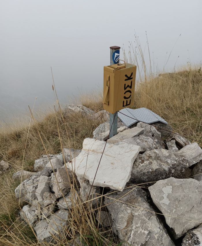
Coming down, we followed the ridge to a lower peak at around 1.915 m of altitude and then started to descend, following the signs with red dots on a yellow background.


The trail, particularly in its lower section, is relatively steep and covered with small stones, adding to its slippery nature.
Upon reaching a saddle at an altitude of around 1,600 m, we turned right, descending and following the well-marked path.
At 1,520 m, a sign indicates the direction to Anthiro (to the left). This segment of the path is labeled as K2.

At a distance of 500 m further down the path, an earth road arrives.

Coming down to 1.295 m, there is one more sign indicating the direction to Anthiro through the path marked K6 by the Climbing Association of Karditsa.
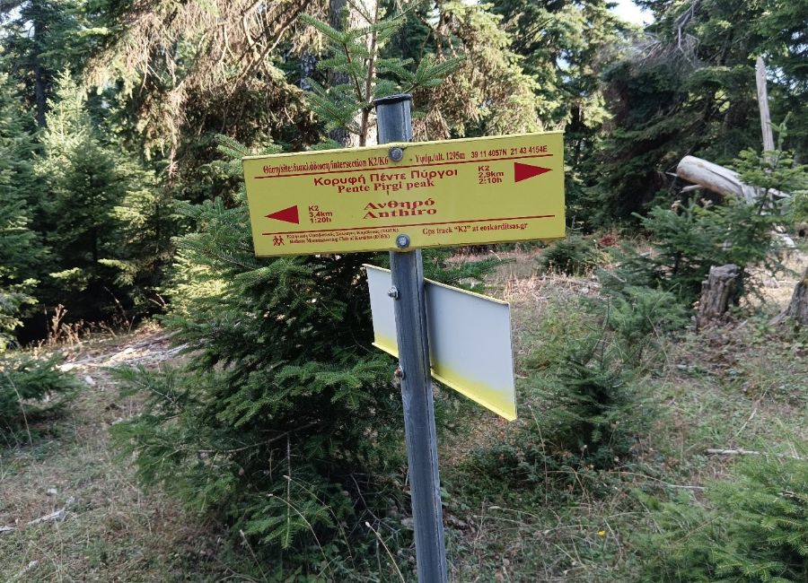
From that point onward, we followed the earth road, taking three shortcuts until we finally followed the path which, after leaving the spruce tree area, enters an oak tree forest.
The marking of the shortcuts is not always clear. Sometimes the signs are on trees far from the road. Eventually, the path led us to the village of Anthiro.
Wikiloc Map for Agrafa Five Towers
Find here the Wikiloc record titled “Agrafa 2 – Petralona – Five Towers – Anthiro” I recorded.
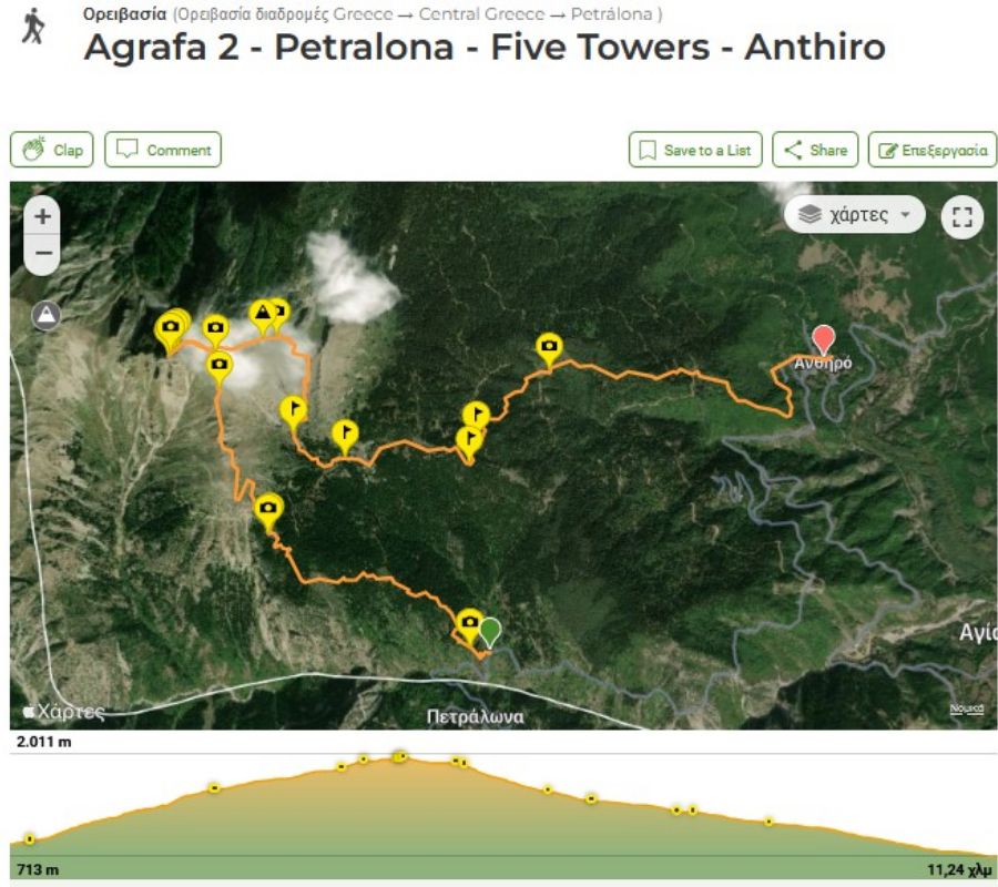
The Climbing Association of Karditsa (AOΣΚ) has posted on their website a trail from Petralona to the Flytzani peak (K3) and one from Anthiro to Five Towers (K2).
You can find them, along with maps of the Agrafa paths, on their website (also in English). All paths can be downloaded in GPX format.
When is the best time to hike?
Agrafa is accessible all year round, but your experience will change with the seasons.
In winter, the conditions are much more difficult due to low temperatures and biting winds.
However, seeing the spruce trees blanketed in snow surrounding the artificial lake is a spectacular sight, even if you don’t reach the summit.
If you love fall colors, the beech and oak trees offer a stunning palette of yellow and red from late October to November. We personally completed this hike in mid-October and found it to be a perfect time for the trails.
What are the physical requirements for this hike?
While the path is not especially demanding in fair weather, you do need to be in good physical condition. You will be tackling an altitude difference of ~1,300 m (~4,265 ft), and the final push to the top is quite challenging.
[!CAUTION] Acrophobia Warning: The final approach to the peak involves exposed sections. If you suffer from a fear of heights (acrophobia), we recommend not attempting to reach the absolute summit.
What gear do I need for the Agrafa trails?
Hiking poles are highly recommended, especially for the steep terrain near the top. Even if it feels warm at the start, bring a fleece jacket; the final ridge is often very windy. For winter treks, you will need full thermal protection and high-quality rainproof gear to stay safe.
Is there water available along the route?
No. Unlike some other Greek ranges, you will not find a water source on this specific trail. It is essential to carry enough water to last the entire journey—we recommend at least 2 liters (~0.5 gallons) per person.
Day 3 in Agrafa to Svoni Peak
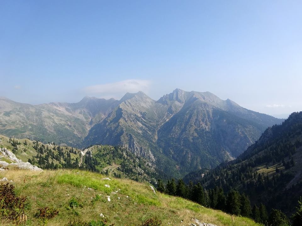
On the third day of our expedition to the Agrafa mountain range, we climbed to Svoni peak (2.040 m), a peak lying to the south of the other two (Borlero and Five Towers) reached on the previous days.
The usual starting point is the village of Petralona. The total altitude difference is 1.100 m and the elevation gain is 1.720 m.

As we were rather tired from the two previous days, we chose the easy way up. We started our hike at an altitude of 1.650 m, so we could spend just 1.30’ to reach the top.
For the rest of the day, we visited the nice village of Agrafa, surrounded by mountain peaks, and the nice tavern a little bit further down the road, near the stream and the small trout farm.
The distance between Anthiro and the trailhead is 16,5 km, and it takes around 40’ by car to cover it. Note that approximately the first half only is an asphalt road, while the second half is an earth road in good condition.

It is, however, good to enquire about the state of the road as this can be damaged by rain over the years if not properly maintained.
In addition to the path we registered in Wikiloc (see below), you may also find a more difficult path starting from Petralona village, leading to Svoni peak, with a total length of 14,4 km (back and forth) and an elevation gain of 1.700 m, requiring the use of climbing ropes at a few points.
Technical information for the Svoni Peak hike

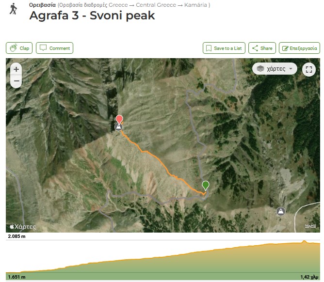
- Trail: 1,4 km (one way to the peak only).
- Elevation: From 1.650 m to 2.040 m, Elevation gain: 390 m, Elevation loss: 390 m.
- Total Time: around 1.30 hours under good weather conditions.
- Level of Difficulty: Moderate to difficult. The difficulty consists in walking on a narrow, rocky and exposed ridge, close to the top. It is also necessary to scramble at certain points.
- Terrain: Earth path, rather steep, with stones at the beginning, rockier close to the top. Entirely in the alpine zone. Some scrambling is necessary.
- Best time to hike: All year round. In winter the conditions are much more difficult because of the low temperature and the cold wind. There is also the possibility of snow in winter which makes scrambling more difficult. We hiked in mid-October.
- Participation Requirements: Not especially demanding under good weather conditions. However, a good physical condition is required due to the need for scrambling. People suffering from acrophobia should not follow this path.
- Gear: Hiking boots will be useful. A fleece jacket may be needed as the ridge may be windy. In winter, you will need warmer clothing and rainproof gear.
- Water: You will not find a water source on the trail, but you will not need a high quantity of water as this is a short trek.
Svoni Trail Breakdown
The trailhead is on the road leading from Petralona (or Saika) village to Agrafa village, 16,5 km after Petralona, close to a right turn at a mountain pass, at an altitude of 1.650 m.
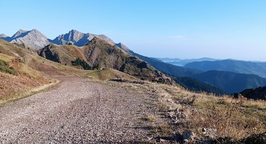
After the first half of the length, the terrain becomes rockier and you will need to scramble to reach the ridge. The path is quite narrow at some points. Do not follow this trek if you are acrophobic.

On the other hand, the 360⁰ view from the top will compensate you.
You will see the artificial lake to the north, as well as the peaks of Borlero and Five Towers we reached on the previous days, the grazing fields of Niala and Kamaria to the west, and the peaks of the Agrafa mountains, in the Evrytania Department, to the south.

Here is the Wikiloc record named “Agrafa 3 – Svoni peak”
After coming down, we continued, by car, the same earth road, to the village of Agrafa. Some 4 km away from the trailhead there is a junction shown below, named Kamaria pass.

If you follow the direction indicated by the arrow, you will reach the village of Agrafa in ten more km or 25 to 30 minutes. In this nice village, surrounded by mountain peaks, there is also a guest house (Kyra Niki).
Where to Stay in Agrafa
Upscale guesthouses are scarce in Agrafa; instead, there are only a handful of properties offering basic amenities. The population of Agrafa villages has notably dwindled in recent decades due to the decline in livestock farming.
Kyra Niki stands out as a welcoming guesthouse in a secluded Agrafa village, representing the top accommodation choice in the area.
For those seeking a more luxurious experience, Pandion Luxury Boutique Hotel & Suites with Spa in Plastiras Lake, located in the highly developed village of Neochori, is recommended.

Camping in villages is also an option. Beyond the summer months, the arrival of tourists is a welcome occurrence for the few locals.
We chose to camp at the central square of Anthiro village. While one must be mindful of cow dung, the overall location was suitable.
There was a fountain and two cafes/restaurants. Mr. Yannis, the owner of one of them, is very amicable towards hikers. It’s worth mentioning that prices in the mountain villages are some of the most affordable in Greece (coffee 1€, beer 2€, main course 5€, salad 2.5€).
How to Get to Agrafa
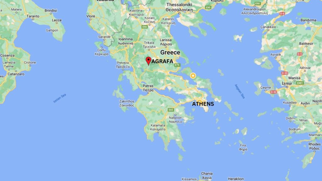
The best way to reach Agrafa from Athens is by private/rental car through the Lamia-Karpenissi National Road. The distance is 325 km, and the estimated cost for tolls and gasoline is 110 euros for a round trip. From Thessaloniki, calculate 300 km and a cost of 120 euros for a round trip. Although the main dirt road is accessible by a regular car, it is advisable to have a 4X4 vehicle with good tires, especially during winter.
What does Agrafa mean?
Agrafa, in Greek, translates to ‘nonwritten’ or ‘non-registered.’ Legend has it that the region earned this name because neither the Byzantine nor the Ottoman empires could effectively collect taxes in this rugged area.
Consequently, it was omitted from their fiscal registers. Additionally, there is a mountain village named Agrafa, situated at an altitude of 840 meters in the heart of the Agrafa mountain range.
Tips for Visiting Agrafa

- Plan Ahead: Book your room in advance and confirm that someone will be there waiting for you. Public transport is rare and doesn’t go everywhere. Rent a car to be independent and move around the region more easily.
- Bring Plenty of Water and Snacks: Hiking in the Agrafa region may involve varying elevations and temperatures, so it’s crucial to stay hydrated. Carry an ample supply of water and pack energy-boosting snacks like trail mix, granola bars, and fruits to keep your energy levels up.
- Respect Nature and Wildlife: Agrafa is known for its rich biodiversity. Respect the local flora and fauna by staying on designated trails, avoiding littering, and refraining from disturbing wildlife. Take only photographs and leave no trace of your visit.
- Inform Someone About Your Plans: Before setting out on a hike, inform a friend or family member about your plans, including your chosen trail, expected return time, and any emergency contacts. This precaution ensures that someone is aware of your whereabouts in case of unforeseen circumstances.
- Respect Local Culture: Agrafa has a rich cultural heritage, and you may encounter local communities during your hike. Be respectful of their customs and traditions. If you plan to visit any villages along the way, consider learning a few basic Greek phrases and being courteous to the locals.
Popular Hiking Destinations in Greece

Hiking in Greece offers a diverse and captivating experience, thanks to the country’s versatile and mountainous terrain. From the rugged mountains of the Pindus range and Vikos Gorge to the north to the Menalon Trail in the Peloponnese to the coastal trails overlooking the Aegean and Ionian Seas, Greece presents a hiker’s paradise.
The country boasts well-maintained paths that wind through ancient olive groves, dense forests, churches, monasteries, ancient ruins, rivers, and charming villages, providing hikers with a unique blend of natural beauty and cultural richness. What are you waiting for? Pack up and discover Greece through hiking!
Did you hike to Agrafa? Let me know what you think about the mountain in the comments. I’d love to hear whether I managed to get it onto your bucket list!
